Rough Seas Ahead?
What to know and where to go if Earl’s friends show up
For those of you who live on boats, work on boats, or are somehow involved in the boating industry, there is no doubt that you are well aware of what time of year it is. That’s right—we are now at the start of another Atlantic-Caribbean hurricane season. And like it or not, preparations must be made.
June 1 marks the beginning of the 2011 hurricane season. Although the tropical hurricane season officially lasts from June 1 until the end of November, the majority of named storms and hurricanes usually occur between the middle of August and October, with the second week of September being the actual peak of the season. However, it is not unheard of to experience a major storm in the early part as well as at the end of the season. For this reason, there is no such thing as preparing too soon or too much for the possibility of being hit by a storm, whether it be great or small.
If you are a first-timer planning to ride out a hurricane with your vessel—whether dockside or on a mooring or anchor—don’t be shy about asking for information from the local salts. I’ve stayed aboard for several major storms and have learned something from each of them. One thing is for sure—they are not fun and are definitely not for the fainthearted.
Constant weather reports and storm tracking become the norm between June and November. If you happen to be one of those people who only gets to see television when you frequent one of your favorite “happy hour” dockside bars, I’m sure you are very familiar with The Weather Channel. It will now out-rate cricket and major league baseball. I’ve seen beautiful women walk into numerous marina bars and be completely ignored when the “tropical update” was on the tube. There is already talk that this may be a busy storm season, and although the storm predictors seem to say this each year, there is nothing like a little fear to boost your level of self-preservation.

According to Sharleen DaBreo, director of the Department of Disaster Management, 112 storms since 1900 have passed within 300 km of the BVI. Every three to six years, the territory has the potential to be affected by a category three or higher storm, she added. And during the latter portion of last year’s hurricane season, we witnessed the brunt of that potential. Hurricane Earl came across the territory with the eventual strength of a category four hurricane, its significant wind speeds and storm surge causing significant damage. But it was the torrential rains that followed—products of passing tropical storms Fiona and Gaston, and hurricanes Igor and Otto—that would drench the territory and cause millions of dollars in structural and infrastructural damage. By the end of 2010, the BVI would record 92.5 inches of rain—more than twice as much than average and about 60 inches more than in 2009, according to DDM statistics. Residents may have breathed a sigh of relief to have the devastating season behind them, but if predictions hold true, we’ll be running for shelter and battering down the hatches again soon.
Scientists at Colorado State University, who have tracked storm and hurricanes in the Atlantic-Caribbean region for many years, have predicted above average activity for 2011. They are calling for at least 17 named storms and 9 hurricanes, with at least 5 classified as major hurricanes. The cast of chaotic characters could include Arlene, Bret, Cindy, Don, Emily, Franklin, Gert, Harvey, Irene, Jose, Katia, Lee, Maria, Nate, Ophelia, Philippe, Rina, Sean, Tammy, Vince and last but not least, Whitney—according to names previously chosen. These potential evildoers could mean devastation for your valued vessel, so it’s important to stay aware of their potential presence, and up to date with weather reports—especially if you leave your boat here and go elsewhere during the summer.
If you are planning to keep your vessel in an acknowledged hurricane zone during the months of June through November, there is a good chance you’ll find yourself prepping for at least one of three basic scenarios. Jera Cameron, manager at Caribbean Insurers Marine Limited (CIML), located in Road Town, provided me with excellent information regarding what insurance companies are looking for when you are making arrangements for an upcoming storm.
If your boat will be laid up “on the hard” ashore, will it be in a cradle? If so, will the mast be un-stepped? When planning to use stands, be sure to use the correct number of them as well as chains to tie the stands together. Also, give serious consideration to the use of straps and ground anchors. While making plans to leave your boat in a yard, be certain to make clear what their responsibilities and liabilities are while your vessel is in their care.
When securing your vessel afloat at a dock, it is imperative that you use not only the correct amount of lines placed in the proper locations, but also the correct size lines. Another important item for securing your boat is the existence and size of stainless steel backing plates for your cleats. Also, don’t forget about the use of correctly placed chaffing gear and fenders. Perhaps most importantly, when making plans to ride out a major storm dockside in a marina, most insurance companies would prefer it if your boat was “double spaced”(tied between two adjacent slips).
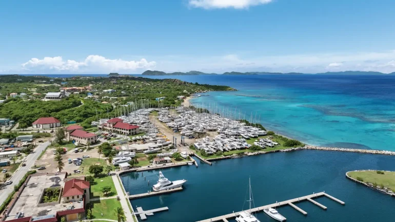
The last scenario to consider when making plans to secure your boat within the “hurricane zone” is keeping it in an acknowledged hurricane hole. Inside Road Harbour, Nanny Cay and Paraquita Bay are three of the better locations on Tortola. If possible, make an effort to use windbreaks such as mangrove swamps within these anchorages. When available, plan to use a combination of both mooring balls and anchors. When mooring balls are not there, it is essential to use more than one well-placed anchor. And once again, appropriate cleats; ground tackle and chaffing gear are extremely important.
No matter how well you have prepared for an oncoming storm, that does not mean that your boat neighbor has taken the same precautions. Know thy neighbour: It only takes one or two errant vessels to wipe out an entire bay full of other boats, no matter how well these boats have readied themselves. This occurs quite often each year.There is no time like the present to start on your hurricane safety plan. Good luck and stay safe!
Editor Dan O’Connor contributed to this story

HURRICANE HOLES
Paraquita Bay, Tortola
Sea Cows Bay, Tortola
Sopers Hole, Tortola
Nanny cay, Tortola (private)
Hodges Creek, Tortola
Inner Harbour, Tortola
Trellis Bay, Beef Island
Hans Creek, Beef Island
The Bight, Norman Island
South Sound, Salt Island
Gorda Sound, Virgin Gorda
Great Harhour, Jost Van Dyke
At this point hurricanes are classified on the SAFFIR – SIMPSON scale:
STRENGTH STORM SURGE WIND SPEED
Category 1 4-5 (ft) 74-95 / 65-82 (mph/kts)
Category 2 6-8 (ft) &
nbsp; 96-110 / 83-95 (mph/kts)
Category 3 9-12 (ft) 111-130 / 96-113 (mph/kts)
Category 4 13-18 (ft) 131-155 / 114-135 (mph/kts)
Category 5 18++ (ft) 155++ / 135++ (mph/kts)